Description
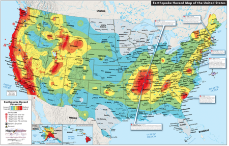
Two-sided series of maps and charts with information about earthquakes, volcanic eruptions, and tsunamis in the U.S. Main map shows earthquake hazard zones in the U.S., including Alaska and Hawaii. The reverse side has information about significant tsunamis, volcanic eruptions, and earthquakes in American history, including a map of the western states with Alaska and Hawaii and a diagram of tectonic plates and continental drift. Measures 17×11, laminated.
This map is customizable and available for licensing! Add your logo, custom locations, or anything else you want to show. Reconfigure and create your own custom product. Contact us to obtain a quote for your customized map.
Made in the USA
